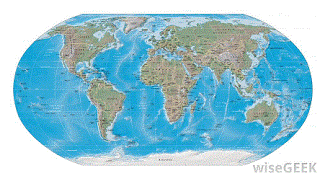
 |
| Not a Mercator Map |
Khambekar's error was easy to spot: in her introduction she mentioned that,
"A Mercator map is a technique [sic] where compass directions are shown as straight lines..."
 |
| Mercator Map |
...therein revealing her ignorance of map projections ("projection" is the word she should have used instead of "technique"), an ignorance she compounded by illustrating a Mercator map with the image shown above. That's not a Mercator map! As Archana told her readers, in a Mercator projection all lines of latitude and longitude cross at right angles, a feature noticeably absent in her chosen image. In reality, a map drawn on a Mercator projection (a word apparently absent from Khambekar's vocabulary) is rectangular and the amount of distortion increases with increasing latitude (see image at right).
Archana's lack of knowledge of maps and map projections resulted in misconceptions and misstatements spread throughout her post. Take, for instance, the notion that,
"Maps of relatively small regions of the Earth such as a state or a province accurately show places, distances, and directions."
Sadly, that would very much depend on your definition of "accurately," Archana. Being off by a few feet would play hell with just about any construction project bigger than the average suburban she shed. Or how about Khambekar's misunderstanding of navigating on a spherical planet?
"Nowadays, airplanes are able to follow shortest routes across the globe; however, such routes do not utilize constant compass directions, but constantly curving routes called 'great circles.'"
|
No, great circle routes aren't used because of map distortion, great circle routes are used because the shortest distance between two points on a sphere is an arc of a circle whose center is the center of the earth but is tilted relative to the equator. It's not a matter of correcting for a projection. Oh, yeah, and a great circle isn't "constantly curving," either – it's a line as straight as the equator. It just looks curved on – you guessed it – a flat map. Duh.
Most of all, however, our staffers were gobsmacked that Khambekar could pound out more than 500 words about Mercator and his map and never use the word "projection." She also missed a chance to educate the public (and herself) by mentioning the Transverse Mercator projection, in which the hypothetical cylinder encircling the earth touches at a line of longitude instead of the equator. Had our Dumbass of the Day been more knowledgeable or more diligent, people might have learned something.
|
But they didn't, hence her award.
SI - MAPS
No comments:
Post a Comment