 |
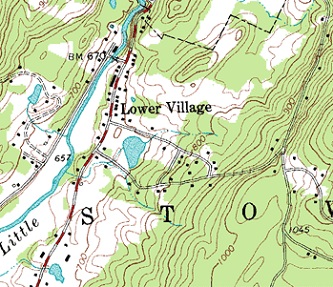
| Example of topographic map detail |
Some of the worst maps ever created appear in advertising, be it online, on paper, or in the yellow pages (remember those?). After trying to use some of those maps our friendly mapmaker is convinced that maps are the original "black box" to many folks. Good news, though: the government organization known as the United States Geological Survey (USGS) publishes inexpensive yet detailed and highly accurate maps of our entire country at several different scales. Unfortunately, amateurs like eHow.com's
Marianne Moro have attempted to explain those maps, with... distressing results; as in her post, "
Land Features on a Topographic Map."¹
We'll say this right up front: the USGS will send you a comprehensive list of every symbol they use on maps, free. Heck, you can find
this guide online in about three seconds... Moro did just that, but she had a few problems with interpreting it. Take, for starters, her first sentence:
"A topographic map shows geological details of a particular region, with contour lines and symbols that represent slopes, mines, vegetation, mud, sand and gravel formations."
No, Marianne, a topo map is not a geologic map. They are quite different animals. What a topo map tells you, if you can read one; is, quite simply, the shape of the land surface and what natural and man-made features are at the surface. By the way, our staff geologist requests that you not misuse the word "formations" in any sentence that includes the word "geology."
Moving on: Moro cribbed all of her details from the USGS pamphlet but her ignorance of the maps still shows in her copy-reword-paste job. Take, for instance, these winners:
|
|
- "...USGS... maps... are used by campers, hikers, scientists and students to identify regions they are visiting or exploring in detail." WTF does "identify" mean in this context, anyway?
- "Closely-spaced contour lines show deep slopes..." We have no idea what a "deep slope" is, Marianne. You probably wanted to say "steep slope."
- "A light green box indicates trees that are 6 feet tall or higher." A "light green box"? don't you mean, "light green shading"?
|
| Moro's ham-fisted attempt to explain the symbology of USGS topographic maps – here, we should note that there are differing versions of the symbology in other countries – contains just enough misinformation to confuse a reader, not to mention that she omitted some pretty important features (water, for instance) entirely. No, this rubbish will not do for information. It will, however do quite nicely for Marianne's Dumbass of the Day presentation. |
|

|
¹ The original has been deleted by Leaf Group, but can still be accessed using the Wayback machine at archive.org. Its URL was ehow.com/list_7450968_land-features-topographic-map.html
copyright © 2017-2022 scmrak
DD - MAPS


No comments:
Post a Comment